Urban Heat Islands : Mapping Urban Heat Patterns using High-Resolution Datasets
Blog > Article > Urban Heat Islands : Mapping Urban Heat Patterns using High-Resolution Datasets
One of the most recurrent territorial demands: to track urban heat islands in a precise manner, at low cost and in real time. This is now possible thanks to the combination of several advanced technologies.
Urban heat refers to the phenomenon where urban areas become significantly warmer than their rural surroundings, a situation commonly known as the 'Urban Heat Island' effect. This occurs because buildings, roads, and other infrastructure absorb and re-emit more heat from the sun compared to natural landscapes. The scarcity of trees and green spaces, combined with heat generated from human activities like vehicles and factories, exacerbates this effect. As a result, cities become noticeably hotter, especially during the summer months, leading to discomfort and potential health issues for residents. Understanding this phenomenon is crucial for developing strategies to mitigate its impact and improve urban living conditions.
The Imperative for Advanced Urban Heat Analytics
Urban heat is not just an environmental issue; it affects public health, infrastructure longevity, and overall quality of life. The ability to accurately track urban heat patterns offers several advantages, including:
- Public Health: Identifying high-heat areas can guide interventions to reduce heat stress among residents, particularly in vulnerable communities.
- Climate Resilience: Understanding urban heat dynamics helps cities design green spaces and reflective surfaces that mitigate heat buildup.
- Infrastructure Planning: High temperatures contribute to the wear and degradation of infrastructure; this data can help prioritize maintenance.
- Energy Efficiency: Knowing where heat is highest can assist in optimizing energy usage and reduce cooling demands.
Given these benefits, there is a clear need for precise, timely urban heat data.
What are the existing types of solutions for monitoring urban heat, and what are their limitations?
Several existing methods are used to monitor urban heat, each with its own strengths and limitations:
- Era5: A reanalysis dataset that provides comprehensive historical climate data, but with limited resolution. It is useful for understanding broad climate trends but lacks the granularity needed for specific, neighborhood-level insights. The coarse granularity makes it impossible to capture neighborhood-specific heat variations, making it nearly impossible to gain actionable insights at the required scale.
- Landsat TIRS: A thermal infrared sensor on the Landsat satellite, providing good spatial resolution. It is valuable for detailed surface temperature mapping but has limited revisit frequency, which restricts its ability to capture real-time temperature changes. Additionally, the sensor can be obstructed by cloud cover or vegetation, affecting data availability. Most importantly however for monitoring the Urban Heat Island effect, Landsat TIRS measures only surface temperature through thermal radiation, not the actual air temperature, which can limit direct relevance to human experience.
- Physical Sensors: Ground-based temperature sensors that offer the most accurate direct measurements. These sensors are ideal for point-specific temperature data but are not feasible for covering an entire urban area comprehensively due to deployment costs and scalability issues. They require prior knowledge of areas where heat issues are expected, making it impractical for comprehensive urban monitoring.
| ERA 5 | Landsat TIRS | Ground Sensor | |
|---|---|---|---|
| High resolution | ❌ | ✅ | ✅ |
| Relevance | ❌ | ❌ | ✅ |
| Cheap | ✅ | ✅ | ❌ |
| Scalability | ✅ | ✅ | ❌ |
Our Approach to Urban Heat Mapping Using High-Resolution Satellite Data
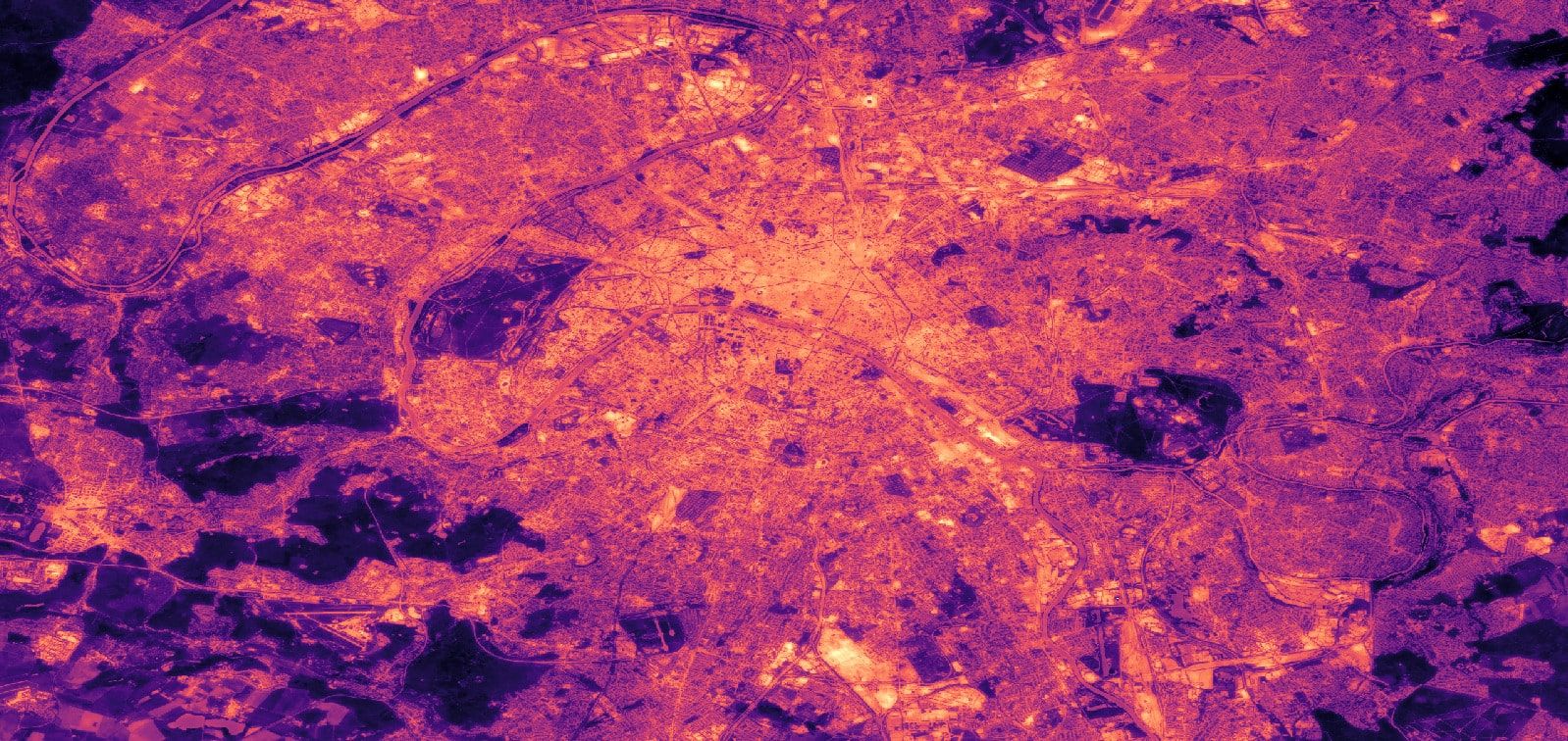
To address the limitations of existing solutions, we combined several approaches, including Era5 and Landsat TIRS, with additional remote sensing features. One of these features is a vegetation index, that helps us incorporate the cooling effect that plants have on their surrounding areas. The remote sensing features are processed through our machine learning model, which has been trained and fine-tuned using data from across the globe. By considering diverse remote sensing features and using global data, our model effectively captures and models the complex relationships between urban areas and air temperatures, at the very high resolution of 10 by 10 meters per pixel, measures multiple times a year.
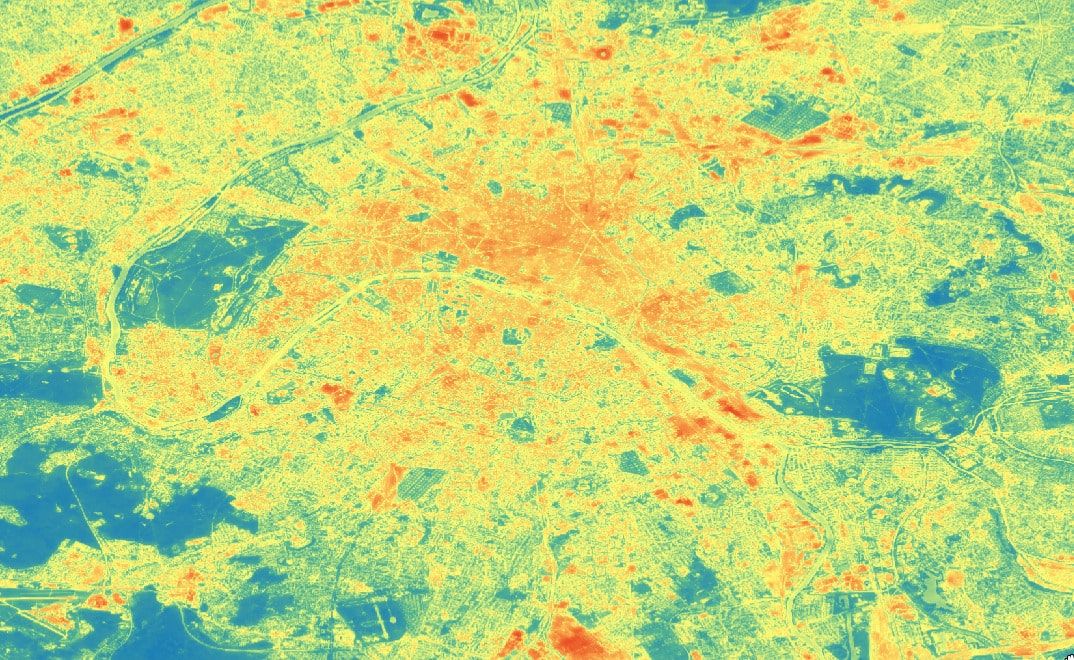
Image of the Urban Heat Island over Paris, showcasing our model high resolutions
High-resolution data at 10 by 10 meters per pixel enables policymakers to take targeted, effective actions to mitigate urban heat. With this level of granularity, urban planners can identify specific heat hotspots down to individual city blocks and even buildings. This allows for the implementation of precise interventions, such as adding vegetation, reflective surfaces, or cooling centers in the most affected areas. Moreover, this data can help prioritize infrastructure improvements, optimize energy usage, and direct resources to vulnerable populations, ensuring that policies can be not only broad-based but also highly localized and impactful. Additionally, this data can be used to validate the effectiveness of the measures taken, providing feedback on how interventions have impacted urban temperatures and allowing for further refinements to the strategies employed.
Contact Us to Learn More
If you’re interested in understanding urban heat patterns in your city, contact us at pierre.blanchet@meteory.eu or by phone on +33 6 49 36 24 91. Our dataset can provide you with the insights you need to create a healthier, more resilient urban environment.

Pierre Blanchet • November 11, 2024
Co-founder of Meteory