Satellites Over Cities: A Comprehensive Look at Urban Monitoring from Space
Blog > Article > Satellites Over Cities: A Comprehensive Look at Urban Monitoring from Space
From tracking city sprawl to assessing environmental impact, discover how satellites are transforming the way we plan and understand our urban landscapes.
In the age of rapid urbanization, the challenges of managing city growth, infrastructure, and environmental impact have become increasingly complex. To navigate this intricate landscape, city planners and policymakers are turning to a perspective that’s both comprehensive and cutting-edge: the view from space. Satellites, once largely the domain of meteorologists and space agencies, are now indispensable tools for urban monitoring and planning. Their ability to capture data—ranging from city sprawl patterns to environmental anomalies—provides unparalleled insights into the state and evolution of urban areas. This article delves into the multifaceted role of satellite data in urban monitoring, exploring its applications, benefits, challenges, and its potential future impacts on shaping the sustainable cities of tomorrow.
The role of satellites in monitoring urbanisation
The use of satellites for Earth observation dates back several decades. In the mid-20th century, when the first Earth-observing satellites were launched, their primary purpose was atmospheric and weather observation. However, it didn't take long for researchers to realize the potential of these platforms for land monitoring. By the late 1970s and 1980s, satellites like Landsat started providing valuable imagery that could detail urban expansion, land use changes, and infrastructure development. As the technology matured, its applications expanded, and urban monitoring emerged as one of its pivotal roles.
The use of satellites for Earth observation dates back several decades. In the mid-20th century, when the first Earth-observing satellites were launched, their primary purpose was atmospheric and weather observation. However, it didn't take long for researchers to realize the potential of these platforms for land monitoring. By the late 1970s and 1980s, satellites like Landsat started providing valuable imagery that could detail urban expansion, land use changes, and infrastructure development. As the technology matured, its applications expanded, and urban monitoring emerged as one of its pivotal roles. One of the significant advantages of satellite-based monitoring is its comprehensive coverage. Satellites can capture imagery of vast areas in a single pass, making it possible to study and compare urbanisation patterns across large regions or even continents. This wide-angle perspective eliminates many of the biases and gaps associated with ground-based methods. Additionally, with repetitive orbits, satellites ensure consistent monitoring, allowing researchers to track changes over time with high precision.
One of the significant advantages of satellite-based monitoring is its comprehensive coverage. Satellites can capture imagery of vast areas in a single pass, making it possible to study and compare urbanisation patterns across large regions or even continents. This wide-angle perspective eliminates many of the biases and gaps associated with ground-based methods. Additionally, with repetitive orbits, satellites ensure consistent monitoring, allowing researchers to track changes over time with high precision.
Satellite technology has democratised data access, enabling not just large organisations but also local municipalities, researchers, and even citizen scientists to study urban patterns. As cities sprawl, merge, and evolve, satellites provide a reliable and timely means to capture these dynamics. Their consistent data stream empowers decision-makers with actionable insights, shaping policies and strategies that accommodate the demands of growing urban populations while ensuring sustainability and resilience.
Types of satellite data used for urban monitoring
Satellite technology has come a long way, offering a plethora of data types that cater to diverse urban monitoring needs. Understanding these data types is essential for leveraging their full potential. Here's a breakdown:
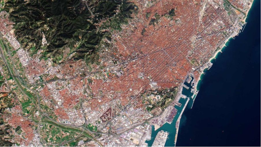
Optical imagery This is perhaps the most familiar form of satellite data. Optical sensors capture images similar to how our eyes perceive the environment, though often at resolutions and scales far beyond human capabilities. High-resolution optical imagery is invaluable for identifying infrastructural developments, delineating urban boundaries, and assessing land use changes. Platforms like Landsat and Sentinel-2 have been instrumental in providing consistent optical data over the years.
Synthetic Aperture Radar (SAR) Unlike optical sensors that rely on visible light, SAR uses radio waves. This capability means SAR can operate regardless of weather conditions or daylight, making it particularly useful for areas frequently clouded or with extended periods of darkness. SAR can provide insights into building densities, urban topology, and even sub-surface structures, given its ability to penetrate certain materials.
Infrared and thermal imagery Cities often behave differently than their rural surroundings in terms of temperature—a phenomenon known as the Urban Heat Island effect. Infrared and thermal sensors on satellites can detect these temperature differences. This data is crucial for understanding energy consumption patterns, assessing urban health risks, and planning green spaces to mitigate heat effects.
The richness and diversity of satellite data available today make it possible to capture a multi-dimensional view of urban landscapes. By integrating various data types, urban planners and researchers can derive nuanced insights into city dynamics, ensuring that urban expansion is monitored holistically and not just in isolated silos.
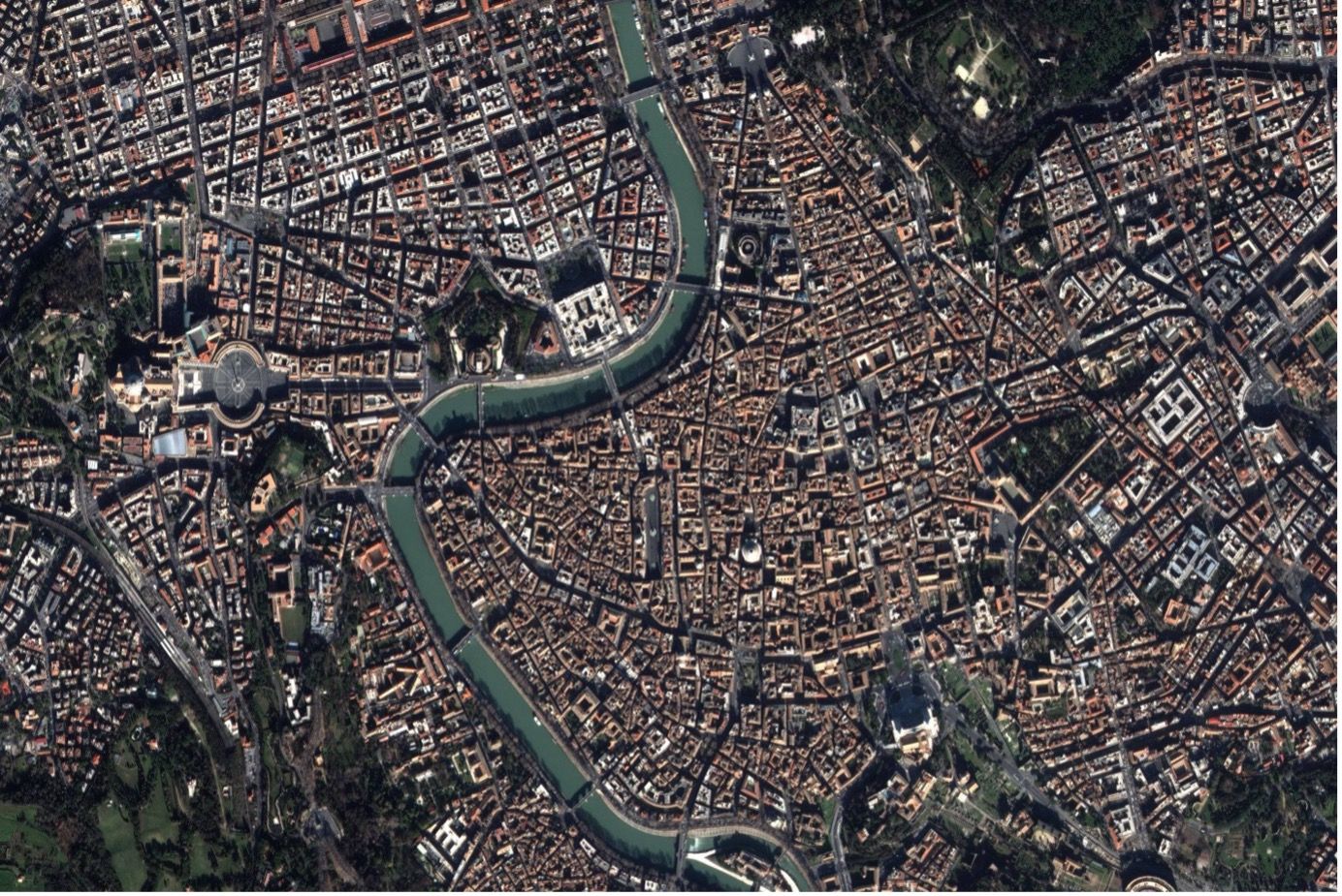 Optical imagery
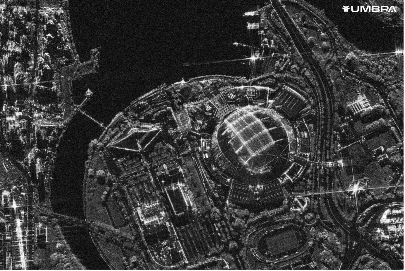 Synthetic Aperture Radar (SAR)
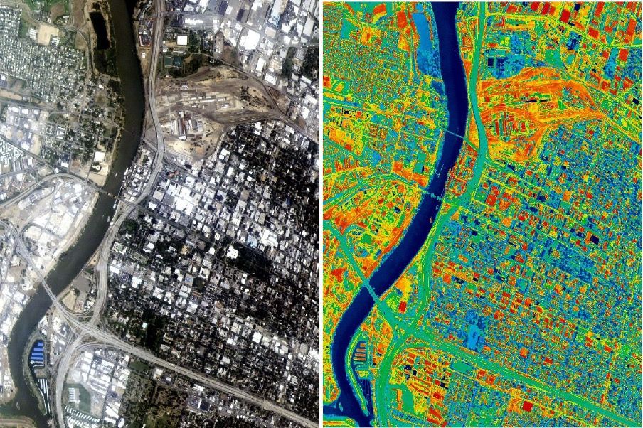 Thermal imagery
Techniques and analyses used for urban monitoring
The raw satellite data, while valuable, requires sophisticated analytical techniques to transform it into actionable insights. Over the years, various techniques have been developed and refined to interpret and process this data effectively. Here's an overview:
Time-series analysis Satellites, especially those in long-term missions, provide a consistent stream of data over the years. Time-series analysis involves examining this data chronologically to observe and quantify changes. In the context of urban expansion, this allows planners to track the pace of development, identify high-growth zones, and anticipate future trends.
Land cover classification Differentiating urban areas from forests, water bodies, and other land types is pivotal. Land cover classification techniques process satellite imagery to categorize different parts of the image into distinct land cover classes. Advanced algorithms and machine learning models are now employed to improve the accuracy and granularity of these classifications, enabling precise demarcation of urban boundaries.
Change detection algorithms Beyond just classifying land types, it's essential to pinpoint where significant changes are occurring. Change detection algorithms compare satellite images from different time points to identify areas of rapid transformation. This can highlight not just urban expansion, but also instances of urban decline, helping policymakers address both growth and decay in urban landscapes.
The analytical techniques employed on satellite data play a pivotal role in deciphering the stories hidden within pixels and wavelengths. With advancements in computational power and artificial intelligence, the potential to glean deeper insights from this data continues to grow, offering a detailed and dynamic picture of urban evolution.
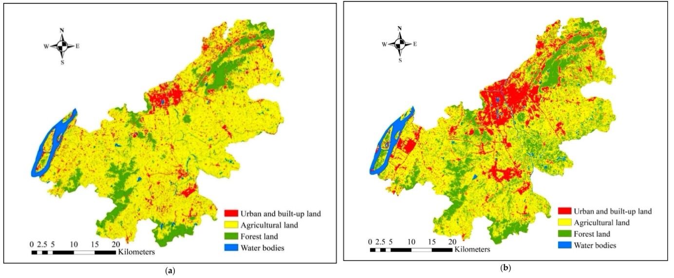 A combination of land cover classification and time-series analysis
Benefits of satellite monitoring for urban planning
The insights derived from satellite data aren't just academic exercises. They hold tangible value for urban planning and development, directly influencing the quality of life for city residents. Let’s explore some of the core benefits:
Urban heat management The phenomenon of Urban Heat Islands, where urban areas experience significantly higher temperatures than their rural surroundings, is a growing concern in city planning. Satellite data, especially thermal imagery, can map and monitor these heat zones. By identifying areas with high heat retention, planners can strategize on introducing green roofs, enhancing urban green spaces, and using reflective building materials to mitigate the UHI effect. This not only contributes to the overall comfort and health of city dwellers but also has implications for energy consumption and greenhouse gas emissions.
Proactive planning With time-series analysis, city planners can anticipate growth trends. This predictive capability enables the proactive design of infrastructure, ensuring that facilities like roads, public transportation, and utilities are not just reacting to present needs but are also prepared for future demands.
Sustainable development Balancing urban expansion with environmental preservation is a challenge. Satellite data, especially when combined with land cover classification techniques, helps planners identify green spaces, wetland areas, and other ecologically sensitive zones. Armed with this knowledge, cities can prioritise sustainable growth, ensuring that urbanisation doesn't come at the expense of ecological health.
Infrastructure and resource allocation Not all urban areas grow at the same pace. By identifying high-growth zones, city administrators can allocate resources more efficiently. This might mean prioritizing road repairs in one district, expanding public transportation in another, or investing in utilities in emerging urban areas. Such targeted interventions can lead to more efficient budgeting and resource use.
Disaster preparedness and response Natural disasters can be particularly devastating in densely populated urban areas. Satellite imagery, especially when it's near real-time, can help city planners understand vulnerable zones, design evacuation routes, and post-disaster relief strategies. For example, SAR data, which can capture data even through cloud cover, has been pivotal in flood assessments in various global cities.
Social and economic analyses Beyond just physical infrastructure, satellite data, when combined with other data sources, can provide insights into socio-economic patterns. Understanding where commercial zones are expanding, how residential areas are transforming, or where public spaces are most utilized can influence policies that improve the overall quality of urban life.
In essence, satellite data has elevated city planning from a reactive discipline to a more proactive, informed, and strategic field. With the world becoming increasingly urbanized, leveraging this space-based perspective is not just beneficial—it's imperative for building the sustainable cities of the future.
Potential challenges and limitations
While satellite data has revolutionised urban monitoring, it's essential to recognise its potential challenges and limitations. A balanced perspective ensures that the data is utilised effectively, without over-relying on it or misinterpreting its findings.
Resolution constraints Even with advancements in technology, satellite imagery has its limits in terms of resolution. While they provide excellent broad-scale views, very fine details might be missed or appear blurred in satellite images. Some urban planning tasks may require on-ground surveys or drone imagery to get more granular data.
Temporal limitations While many satellites have frequent revisit times, they might not capture changes that occur very rapidly. Depending on the satellite and its orbit, there can be gaps between image captures, leading to potential missed observations.
Data interpretation Satellites provide raw data, which then requires processing and interpretation. There's always a margin of error involved, especially if data isn’t calibrated correctly or algorithms misclassify certain features. Skill and expertise are crucial for accurate interpretation.
Cost implications While many satellite datasets, like those from Landsat or Sentinel, are freely available, high-resolution commercial satellite imagery can be expensive. Ensuring continuous monitoring using such data sources might be cost-prohibitive for some cities or organisations.
Environmental factors Satellite sensors, especially optical ones, can be hampered by environmental factors. For example, persistent cloud cover in certain regions might obscure the ground, making consistent monitoring challenging. While SAR can overcome this, it brings its own set of challenges and might not always be a viable substitute.
Recognising these challenges and limitations is pivotal for urban planners and decision-makers. It ensures that satellite data is used in conjunction with other data sources and methodologies, ensuring a comprehensive and holistic approach to urban monitoring and planning.
The future of urban monitoring through satellite data
The trajectory of satellite technology, coupled with rapid urbanization, promises an evolving landscape for urban monitoring. As we look ahead, several exciting developments are on the horizon:
Higher resolution satellites As satellite technology continues to advance, we can expect even higher resolution imagery to become available. This will allow urban planners to discern finer details, making satellite data even more valuable for tasks that currently rely on ground surveys or aerial imagery.
Real-time monitoring With the proliferation of satellite constellations and miniaturised satellite tech (like CubeSats), the possibility of near real-time monitoring of urban areas is becoming a reality. Such capabilities can revolutionise response mechanisms, from traffic management to emergency responses.
Integration with AI and machine learning Advanced algorithms and machine learning models are set to play a pivotal role in processing and interpreting satellite data. These technologies can automate many aspects of urban monitoring, providing insights faster and potentially with greater accuracy.
Data fusion Future urban monitoring will likely involve integrating satellite data with other data sources. Combining satellite imagery with data from IoT sensors, social media platforms, and other datasets can provide a multi-dimensional understanding of urban landscapes, from physical changes to social dynamics.
Democratisation of data With increased access to satellite data and user-friendly analytical tools (such as the Meteory platform), a broader range of stakeholders—from local municipalities to citizen scientists—will engage in urban monitoring. This democratisation can lead to more inclusive urban planning processes, incorporating diverse perspectives and localised insights.
While the future is promising, it also underscores the importance of continued investments in satellite technology and the analytical tools that support it. As cities continue to grow and evolve, the bird's-eye view from space will become even more critical in steering their trajectories towards sustainability, resilience, and prosperity.
Conclusion
Urbanisation, with its myriad challenges and opportunities, stands as one of the defining phenomena of the 21st century. The growth and evolution of our cities will have profound implications not just for their residents, but for the planet as a whole. In this dynamic landscape, the role of satellite data in urban monitoring cannot be overstated.
From tracking the sprawling expanse of mega-cities to highlighting the subtle environmental shifts induced by urban growth, satellite imagery provides an unparalleled perspective. It bridges the gap between ground-level observations and a more holistic, aerial view, giving planners and policymakers the comprehensive insights they need to make informed decisions.
Yet, as with any tool, it's crucial to understand both its capabilities and limitations. The power of satellite data lies not just in the pixels captured but in the expert analyses and interpretations that transform these pixels into actionable insights. As we move forward, the synergy between technological advancements in satellite imaging and progressive urban planning methodologies promises to shape the cities of tomorrow.
In an increasingly interconnected world, the ability to observe, understand, and act upon the patterns of urban growth from space is not just an advantage—it's a necessity. And as the eyes in the sky continue to watch over our ever-evolving urban landscapes, one thing becomes clear: the future of urban planning is intrinsically linked to the view from above.

Hein de Wilde • May 31, 2024