How Satellite Data Is Used to Detect Deforestation
Blog > Article > How Satellite Data Is Used to Detect Deforestation
Satellite technology fulfils an important role in monitoring forests globally. Discover the opportunities, techniques, and challenges of detecting deforestation from space.
Satellite technology fulfils an important role in monitoring forests globally. Discover the opportunities, techniques, and challenges of detecting deforestation from space.
Forests play a pivotal role in the global environment and economy. From carbon sequestration to supporting biodiversity and providing livelihoods for millions, their importance is undeniable. However, the world's forests are under threat, with large swathes disappearing each year due to deforestation. To combat this, professionals globally are turning to satellite technology. Through the eyes of these satellites, we gain a comprehensive view of forest cover changes, allowing for timely detection and intervention. This article delves into the intricacies of satellite-based forest monitoring, exploring the technologies, techniques, and applications in the fight against deforestation.
The importance of forests
Forests are more than just vast expanses of trees and vegetation; they are intricate ecosystems that serve crucial functions on both local and global scales.
Climate regulation Forests act as the planet's thermostat. They absorb carbon dioxide, a major greenhouse gas, and release oxygen in return, making them vital for the balance of our atmosphere. This function is especially crucial in the face of global climate change, as forests have the capacity to offset a significant portion of human-induced carbon emissions. Biodiversity Home to more than 80% of terrestrial species, forests are reservoirs of biological diversity. From the smallest insect to the largest mammals, they provide habitats that are essential for the survival of countless species. Human livelihoods Approximately 1.6 billion people, including many indigenous communities, rely on forests for their livelihoods. Forests offer resources such as timber, medicinal plants, and food, playing a direct role in the socioeconomic well-being of a significant portion of the world's population. Water cycle regulation Forests play a pivotal role in the water cycle. Through a process called transpiration, trees release water vapor into the atmosphere, influencing rainfall patterns and freshwater availability in many regions.
The interwoven relationship between forests and life on Earth underscores their immense value. Protecting them is not just an environmental imperative but also a requisite for socioeconomic stability and biodiversity conservation.
The global crisis of deforestation
Deforestation, the large-scale removal or degradation of forests, is an urgent global crisis. The consequences are manifold, affecting both our environment and societies in profound ways. Each year, an estimated 10 million hectares of forest are lost, roughly the size of Iceland. While some of this loss is offset by forest growth and replanting, the net annual decrease in forest area over the past decade is approximately 4.7 million hectares. The consequences of such significant forest loss include: • Carbon emissions: Forests act as carbon sinks, storing large amounts of carbon dioxide. When forests are cleared, especially through burning, they release this stored carbon, contributing to global greenhouse gas emissions. • Biodiversity loss: Deforestation threatens the habitats of countless species, leading to reductions in biodiversity. Many species, especially those endemic to specific forest regions, face the risk of extinction. • Soil degradation: Forests maintain soil health by preventing erosion, enriching the soil with organic matter, and regulating water flow. Their removal can lead to diminished soil fertility and increased vulnerability to natural disasters. • Societal implications: Many communities, particularly indigenous populations, depend directly on forests. Deforestation disrupts their way of life, often leading to conflicts over land and resources.
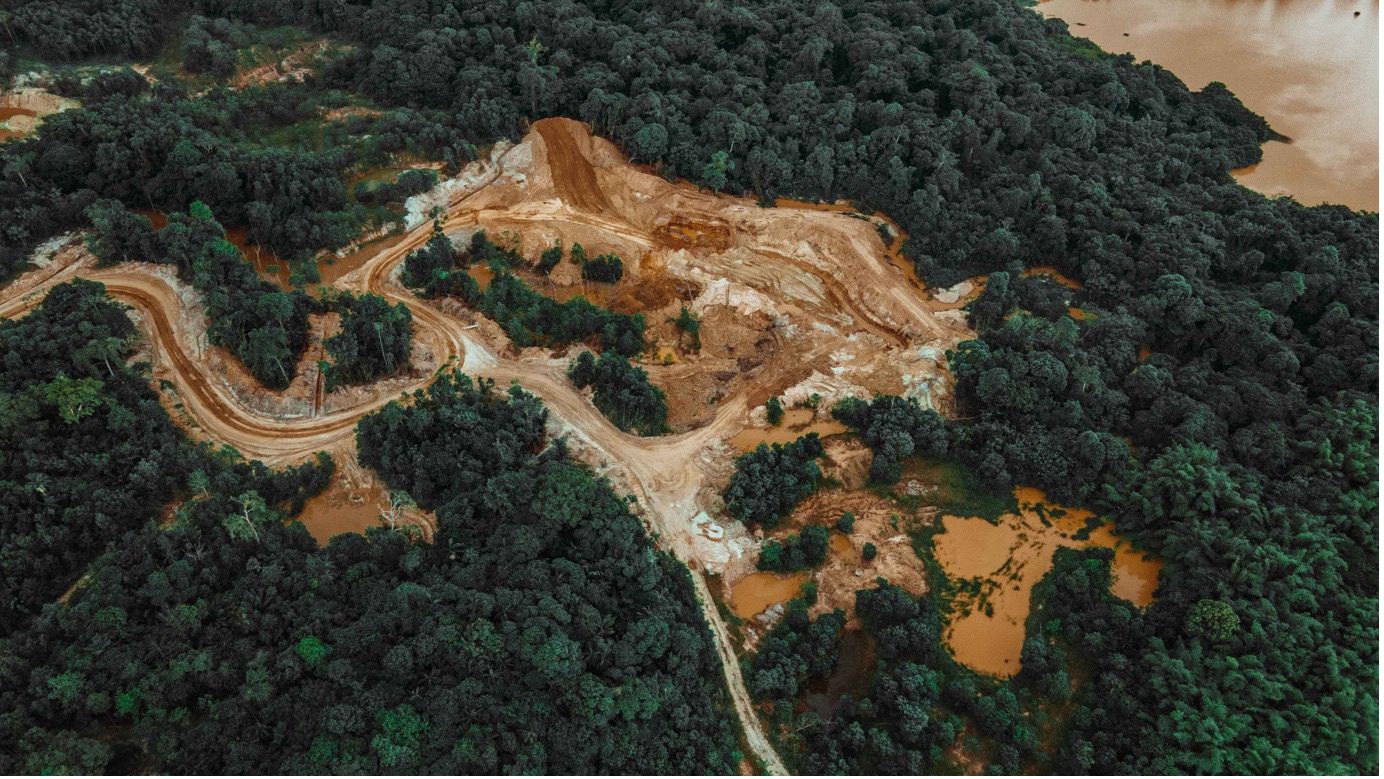
Many regions around the world are facing large-scale deforestation. The Amazon, often referred to as the "lungs of the Earth", has seen alarming rates of forest loss, primarily for cattle ranching and agriculture. Regions in Southeast Asia, such as Borneo and Sumatra, are witnessing rapid deforestation due to the expansion of palm oil plantations. And the Congo Basin, the world's second-largest tropical forest located in Central Africa, faces threats from logging, mining, and the bushmeat trade. The gravity of the deforestation crisis necessitates a concerted global response. The application of modern technologies, like satellite-based monitoring, offers promise in addressing and mitigating these challenges.
 Deforestation near Porto Velho, Brazil (AP Photo/Andre Penner)
How satellites detect deforestation
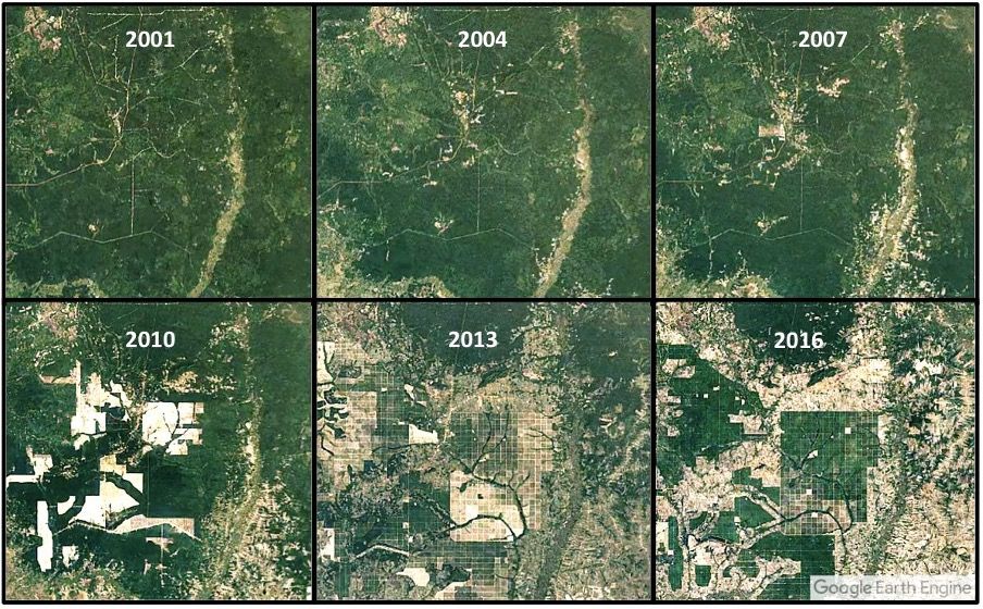
The vastness of global forests poses a challenge for monitoring on the ground. This is where satellite technology comes to the fore, offering a comprehensive, timely, and efficient means to keep tabs on forest cover changes. There are several types of satellite sensors that are used for detecting deforestation: • Optical sensors: These capture images in visible light, much like a standard camera, but can also detect non-visible wavelengths, enabling them to monitor vegetation health and moisture content. • Radar sensors: Using radio waves, radar sensors can penetrate clouds and even capture data at night. They're particularly useful in regions with frequent cloud cover or in assessing structural characteristics of forests. • Thermal sensors: Detecting radiation in the infrared spectrum, these sensors are instrumental in identifying forest fires and areas of heat stress in forests. One of the key advantages of satellite monitoring is the ability to capture sequences of images over time, which is also known as time-series data. Such data facilitates tracking of gradual changes in forest cover and helps distinguish between temporary shifts (like seasonal changes) and permanent ones (such as deforestation). Furthermore, satellites can often distinguish the cause of forest cover change. For instance, the clear-cut patterns of logging differ from the more scattered, irregular patterns of shifting cultivation. Similarly, the aftermath of natural disturbances, like hurricanes or pest infestations, can also be discerned. Leveraging these capabilities, satellites provide invaluable insights into the state of our forests. Their data, when processed and analyzed, forms the backbone of many forest conservation strategies and initiatives around the world.
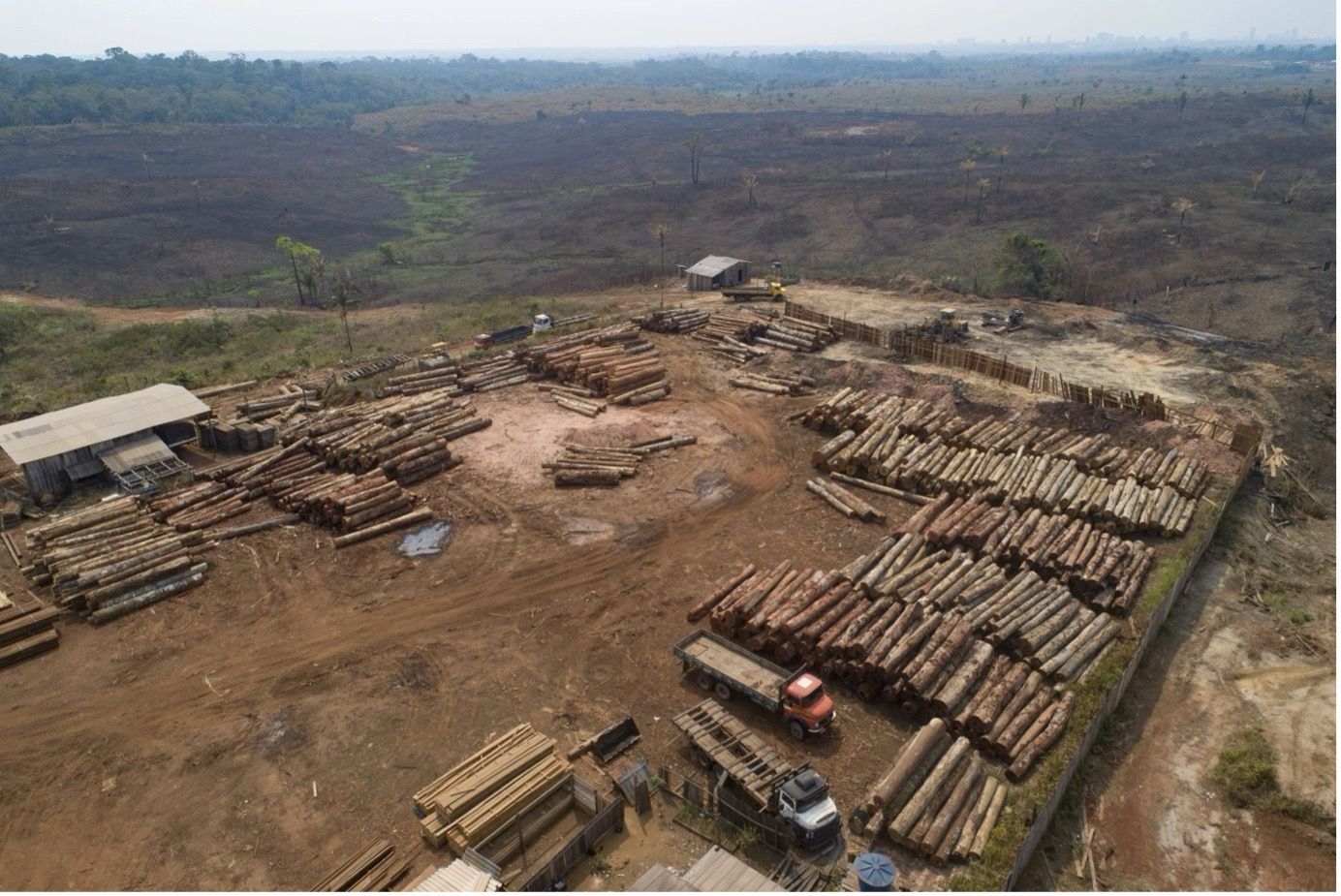
 Deforestation due to rubber plantations
Techniques and analyses
Satellite data, while invaluable, is most effective when complemented by advanced analytical techniques. These techniques transform raw satellite imagery into actionable insights that can guide conservation efforts.
Spectral analysis Satellites capture data across multiple wavelengths, some beyond human vision. Spectral analysis involves examining these different wavelengths to identify specific materials on the ground. For example, healthy vegetation reflects light differently from stressed or dead vegetation. By analyzing these spectral signatures, scientists can assess forest health and detect early signs of degradation.
Machine learning and AI Modern computing brings the power of machine learning to satellite data analysis. Algorithms can be trained to recognize patterns associated with deforestation, such as the layout of roads leading to logging areas or the distinctive shapes of clear-cuts. Once trained, these models can rapidly scan vast areas, pinpointing potential sites of deforestation with high accuracy.
Data fusion Often, a holistic understanding of forest health requires integrating data from multiple sources. This can include combining optical, radar, and thermal satellite data or integrating satellite imagery with ground-based observations. Such fusion provides a more comprehensive view of forests, improving the accuracy of deforestation assessments.
Change detection This involves comparing satellite images taken at different times to identify changes in land cover. By overlaying and analyzing images from different periods, researchers can detect and quantify forest loss, distinguishing it from other land cover changes like seasonal vegetation shifts.
Geospatial analysis Geographic Information Systems (GIS) allow researchers to layer satellite imagery with other geographical data, such as topography, human settlements, or infrastructure. This facilitates a deeper understanding of the factors driving deforestation in specific regions.
Harnessing these techniques, researchers and conservationists can derive nuanced insights from satellite data, ensuring that deforestation detection is timely, accurate, and actionable.
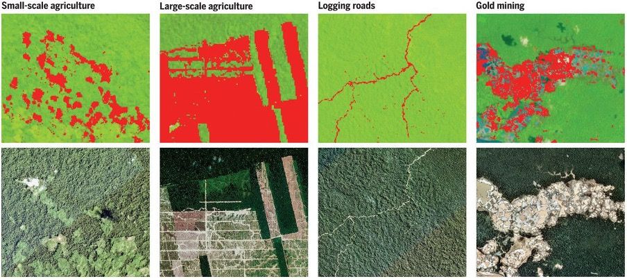 Differentiating different types of deforestation from satellite imagery
Case studies
The application of satellite data and advanced analysis techniques has proven invaluable in various global contexts. Here are some noteworthy case studies that highlight the effectiveness and impact of this approach:
The Amazon Rainforest In recent years, the Brazilian government and NGOs have employed the use of satellites to track deforestation in the vast expanse of the Amazon. Through near real-time monitoring, authorities have been able to swiftly identify illegal logging activities and deploy enforcement teams on the ground. The system, known as DETER (Real-Time Deforestation Detection System), has been instrumental in curbing illicit deforestation in certain parts of the Amazon.
Borneo and Sumatra With the rapid expansion of palm oil plantations threatening biodiverse-rich forests, conservationists have harnessed satellite data to monitor land use changes. The ability to detect newly constructed roads, a precursor to logging and plantation activities, has allowed early interventions and advocacy efforts targeting specific companies or supply chains.
Central African Forests In the Congo Basin, satellite monitoring has aided the detection of logging activities in protected areas. Collaborative efforts between international NGOs and local communities have utilized this data to raise awareness and challenge logging permits, ensuring that pristine forest areas remain undisturbed.
California, USA After devastating forest fires, satellite imagery has been employed to assess the extent of damage and to monitor recovery over time. This data assists forest management agencies in prioritizing reforestation efforts and gauging the health of recovering forest patches.
Each of these cases underscores the transformative power of satellite technology. Not only does it enable the detection of deforestation, but it also empowers communities, governments, and organizations to take decisive, informed action against environmental degradation.
Challenges in satellite-based forest monitoring
While satellite technology offers an unparalleled advantage in monitoring forests on a global scale, it's essential to understand its limitations and the challenges faced in its application.
- Resolution limitations The resolution of satellite imagery varies. While high-resolution imagery can provide detailed insights, such data may not always be available for all regions or may be expensive to procure. On the other hand, lower-resolution imagery, while covering larger areas, might miss small-scale deforestation activities.
- Cloud cover issues Forested regions, especially tropical rainforests, are often cloud-covered. This poses a challenge for optical sensors that can't penetrate clouds, potentially leading to gaps in monitoring.
- Temporal challenges While some satellites pass over the same location daily, others might have longer intervals. This can sometimes mean that rapid deforestation events are missed or not detected in a timely manner.
- Data overwhelm The sheer volume of satellite data can be overwhelming. Processing, storing, and analyzing these vast datasets require sophisticated infrastructure and can be resource-intensive.
- Differentiating natural changes Satellites can detect changes in forest cover, but distinguishing between natural changes (like seasonal leaf drop) and human-induced changes (like logging) can sometimes be challenging without corroborative ground-truth data.
- Access and cost While many organizations and initiatives provide free access to satellite imagery and data, some high-quality datasets might be proprietary and costly. This can limit their use by NGOs or developing nations with constrained budgets.
- Integration with ground data For a comprehensive understanding, satellite data often needs to be integrated with on-ground observations. However, in remote or conflict-prone regions, collecting ground data can be challenging, leaving potential gaps in the overall monitoring effort.
By acknowledging and addressing these challenges, the global community can further refine the tools and techniques of satellite-based forest monitoring, ensuring it remains an effective weapon in the fight against deforestation.
The future of satellite-based forest monitoring
The frontier of satellite technology is ever-expanding, promising even more robust capabilities for forest monitoring in the coming years. Here's a glimpse into the future possibilities:
Increased resolution Satellites of the future will offer even higher resolution imagery, allowing for detailed analyses of smaller patches of forest. This enhancement will enable conservationists to detect minor changes and disturbances, further improving the accuracy of monitoring efforts.
Frequent revisits With more satellites being launched, especially by private players, the frequency of satellite overpasses will increase. This means regions can be monitored more regularly, ensuring timely detection of deforestation events.
Improved cloud penetration Advances in radar and LiDAR technology will allow satellites to better penetrate cloud cover. This will be especially valuable for continuously monitoring cloud-prone regions like the Amazon and Southeast Asian rainforests.
Automated real-time analysis The integration of AI and machine learning will become even more sophisticated, enabling real-time processing of satellite imagery. This means potential deforestation events could be flagged almost immediately after they start, allowing for rapid response.
Satellite constellations Collaborations between countries or organizations might lead to dedicated satellite constellations for forest monitoring. These constellations would offer synchronized, comprehensive coverage of forested regions, ensuring no area remains unmonitored.
The future holds immense promise. As technology continues to advance and international commitment to forest conservation strengthens, satellite-based forest monitoring will undoubtedly play a pivotal role in safeguarding our planet's green cover.
Time to take action
At Meteory, our expertise goes beyond just understanding satellite technology; we harness its potential to deliver tangible solutions for the forestry industry. With our advanced analytical tools and comprehensive datasets, we provide monitoring, predictive analytics, and actionable insights tailored to the unique needs of forestry businesses. Whether you're a conservation agency looking to pinpoint areas of concern or a timber company striving for sustainable practices, Meteory can be your partner in making data-driven decisions for a greener future.
Conclusion
Forests play a critical role in the global environment, economy, and society. Their sustainable management and conservation are essential for climate regulation, biodiversity preservation, and the livelihoods of billions. As deforestation continues to threaten these vital ecosystems, satellite technology has emerged as an indispensable tool for monitoring and protection.
Through the consistent, expansive coverage provided by satellites, stakeholders worldwide can obtain objective, timely data on forest changes. This information is crucial for informed decision-making, policy formulation, and conservation initiatives. However, while the potential of satellite monitoring is vast, it's essential to remain cognizant of its challenges and work towards refining these systems further.
The future for satellite-based forest monitoring is promising. As technology advances, and international collaboration strengthens, the precision, frequency, and accessibility of satellite data will only improve. In combining these technological advancements with global conservation efforts, we are better positioned to safeguard our planet's forests for future generations.

Hein de Wilde • May 21, 2024